Strait of Hormuz: Why This Narrow Waterway Controls Global Energy, Geopolitics & War Dynamics
- Gyan Prakash Satyam

- 2 days ago
- 7 min read
Introduction
The Strait of Hormuz is one of the most strategically important waterways in the world. This narrow passage, located between Oman and Iran, connects the Persian Gulf to the Arabian Sea and global shipping routes. Despite its small physical size, it plays a massive role in global energy security, international trade, and geopolitical tensions — a reality the world is confronting more acutely than ever in 2026. Since February 28, 2026, the ongoing US-Israel war on Iran has once again thrust the Strait of Hormuz into the global spotlight. In retaliation for American and Israeli airstrikes, Iran closed the strait to enemy-affiliated shipping, instantly disrupting roughly 20% of the world's oil supply and triggering what the head of the International Energy Agency described as the greatest global energy security challenge in history. Commercial shipping traffic collapsed by over 90%, Brent crude surged past $100 per barrel, and Europe — already reeling from historically low gas storage levels — was pushed toward a second major energy crisis. The geological reality of the Hormuz region makes this crisis even more consequential. Beneath and around these contested waters lie some of the richest oil and gas deposits on Earth — a legacy of hundreds of millions of years of tectonic activity, ancient salt formations, and vast carbonate platforms. This energy-dense geology is precisely why a conflict here never stays regional: it ripples outward, hitting fuel prices in Tokyo, food prices in Lagos, inflation rates in London, and supply chains across every continent. The World Bank warned in April 2026 that the war is striking the global economy in cumulative waves — first through energy, then food, then inflation, then rising debt costs — underscoring why the Strait of Hormuz remains a perpetual flashpoint of global concern.
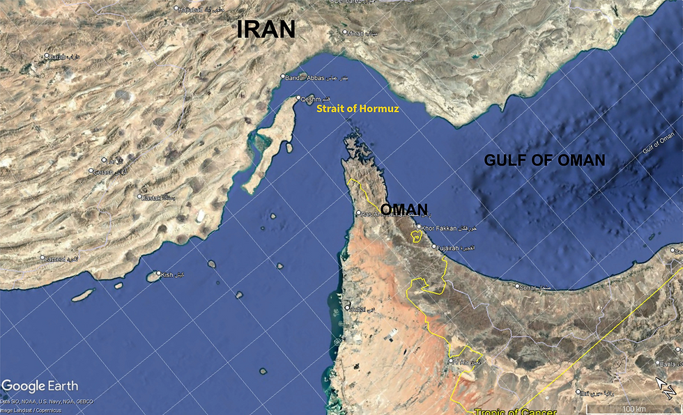
Where Is the Strait of Hormuz and Why Does It Matter?
The Strait of Hormuz serves as the only sea passage from the Persian Gulf to the open ocean. It connects the oil-rich Persian Gulf with the Arabian Sea and global markets, functioning as the essential gateway for a vast share of the world's hydrocarbon exports.
Key Facts at a Glance
• Located between Oman and Iran, at the mouth of the Persian Gulf
• One of the busiest oil transit chokepoints in the world
• Connects major oil-producing countries — Saudi Arabia, UAE, Kuwait, Iraq, Qatar — to global markets
• Extremely narrow, making it vulnerable to disruption during war and conflict
• No viable alternative maritime route exists for Persian Gulf producers
Because of these factors, even a small disruption can send shockwaves across the global economy.
Why the Strait of Hormuz Is Critical to the Global Economy?
The global significance of the Strait of Hormuz is defined by several deeply interlinked economic and strategic factors:
1. A Vital Energy Artery
The strait carries an enormous share of the world's crude oil and liquefied natural gas (LNG) exports every single day. Approximately 25% of the world's oil is produced by countries surrounding the Arabian Gulf, and almost all of it is shipped through this narrow corridor. Any disruption — especially during war — can trigger sharp increases in fuel prices and widespread economic instability.
2. A Critical Commodity Corridor
Beyond crude oil, the waterway is indispensable for transporting other critical resources. For example, approximately 36% of the world's helium — produced primarily in Qatar — is shipped through the Strait of Hormuz. At least a dozen LNG tankers pass through the strait every day, supporting a global market heavily dependent on this commerce.
3. Global Economic Interdependence
Global economies are deeply interconnected. Nations from East Asia to Europe rely on uninterrupted shipping through the Strait of Hormuz. A blockade during war could disrupt supply chains, raise energy costs, and trigger economic recessions across multiple continents simultaneously.
4. Strategic Geopolitical Leverage
Due to its narrow geography and the absolute lack of practical alternatives, the strait holds immense strategic value. Control over the Strait of Hormuz becomes especially critical during war scenarios. Even the mere threat of closure — via naval mines, missiles, or patrol boats — carries significant economic and strategic consequences for the entire global community.
The Geology of Hormuz: How This Strategic Passage Was Formed
The formation of the Strait of Hormuz is the result of complex tectonic interactions spanning hundreds of millions of years. This involves the deposition of ancient salt layers, massive continental collisions, and relatively recent sea-level changes that transformed a dry plain into the world's most critical maritime chokepoint.
The Deep Foundation: Ancient Salt and Carbonate Platforms
The earliest geological foundations of the region date back to the Ediacaran (Late Neoproterozoic) to Early Cambrian period, when the Hormuz Formation was deposited. This sequence consists of thick evaporites — primarily rock salt (halite), gypsum, and anhydrite — which formed in basins created by extensional tectonics. These weak salt layers later became crucial as a 'decollement' or geological lubricant level, allowing overlying rock layers to slide and fold during subsequent mountain-building events. From the Permian to the Middle Cretaceous, the area was part of a vast carbonate platform, with massive limestone units deposited in a broad epicontinental sea.
The Age of Collisions: Oman and Zagros Orogenesis
Tectonic activity intensified dramatically during the Late Cretaceous with the Oman Orogeny. This event involved the obduction (over-thrusting) of the Semail ophiolite — oceanic crust and mantle — onto the continental margin of Oman, creating intense pressure and flexural foreland basins. Later, during the Oligocene to Miocene, the Zagros Orogeny occurred as the Arabian Plate continued its collision with the Eurasian Plate. This caused the folding and thrusting of the Earth's crust, forming the Zagros Mountains and reactivating the movement of the ancient Cambrian Hormuz salt, which began to rise as salt diapirs (domes) through the overlying rock.
The Fracture: Role of the Indian Plate
A critical event in the specific formation of the Strait occurred between 55 and 50 million years ago. The Indian Plate was moving northward at an exceptionally high speed. The immense tectonic stress exerted by this rapid convergence is theorised to have fractured the Musandam Mountains, essentially rupturing them from the Eurasian Plate. This tectonic rupture initiated the physical opening of the narrow corridor that would become the Strait of Hormuz.
The Modern Gateway: Quaternary Sea Level Changes
While the structural opening of the Strait is geologically ancient, its current state as a navigable waterway is a remarkably recent development. During the Last Glacial Maximum (LGM), approximately 26,500 to 19,000 years ago, global sea levels were 120–130 meters lower than today. The floor of the Persian Gulf was a dry, arid plain fed by the Tigris, Euphrates, and Karun rivers. As global temperatures rose and ice sheets melted, sea levels climbed, and the region flooded — transforming the dry corridor into the strategic maritime passage we know today, roughly 14,000 years ago.
The Strait of Hormuz transitioned from a dry, river-fed plain into a narrow maritime gateway only about 14,000 years ago — making it one of history's most consequential geological accidents.
Complex Seabed Conditions at the Strait of Hormuz
The condition of the seabed in the Strait of Hormuz is characterised by a mixture of calcareous (shelly) sands, gravels, and significant mud deposits, shaped by both ancient tectonic forces and recent marine processes.
Sediment Composition
• Predominant Materials: Calcareous sands and gravels form the primary seafloor composition
• Mud Content: A significant calcareous mud blanket extends to the north of the main shipping channel
• Physical Properties: Surface shear wave velocity in these sediments measures 15–30 m/s — significantly lower than standard quartz beach sand — affecting underwater acoustics and naval operations
Depth and Historical Context
• The Persian Gulf is a shallow epicontinental sea with an average depth of just 35 metres
• Depths in the Strait of Hormuz itself typically range between 75 and 93 metres
• Approximately 20,000 years ago, this seafloor was a dry, expansive arid plain with extensive dune systems
• The area was inundated by rising sea levels starting roughly 15,000 years ago
Strait of Hormuz and War: The World's Most Dangerous Flashpoint
The Strait of Hormuz is consistently at the centre of geopolitical tensions and war risks. Its strategic value makes it a prime target and an arena for power projection.
Why It Becomes Critical During War
When conflict escalates in the Persian Gulf region, the Strait of Hormuz immediately becomes a focal point for several reasons:
• A naval blockade can completely disrupt global oil supply chains within days
• Military conflict can halt all commercial shipping traffic through the corridor
• Even the credible threat of war causes oil prices to spike on international markets
• Missile attacks or mine-laying can make the passage unsafe for commercial tankers
Strategic Vulnerabilities
Because of its narrow width — only about 33 km at its narrowest navigable point — the strait is uniquely vulnerable to military disruption:
• Naval blockades can be enforced with minimal resources
• Underwater mines can render the passage hazardous for large tankers
• Coastal missile batteries can threaten shipping without direct naval engagement
• Military escalation by any regional power can have immediate global consequences
Environmental and Industrial Risks
The heavy concentration of maritime transport, combined with a vast number of inland and offshore oil platforms, makes the region a naturally stressed environment.
Major Environmental Risks
• Oil spills during accidents or wartime attacks on tankers
• Marine ecosystem damage from chronic pollution and acute incidents
• Industrial hazards due to the exceptionally high density of maritime traffic
• Long-term ecological consequences from any large-scale disruption
Any disruption — whether accidental or deliberate — can have catastrophic ecological and industrial impacts on surrounding nations and far beyond the immediate region.
Conclusions
The Strait of Hormuz is far more than a narrow waterway — it is the backbone of global energy supply, a geopolitical hotspot, and one of the most geologically fascinating passages on Earth. Its structural formation was driven by a tectonic rupture approximately 50 to 55 million years ago, when the exceptionally rapid northward movement of the Indian Plate fractured the Musandam Mountains. This complex evolution was mechanically facilitated by the 540-million-year-old Hormuz Formation salt, which acted as a lubricant during continental collisions and continues to shape the region through rising salt diapirs.
Despite its ancient structural roots, the Strait is a remarkably recent seaway — transitioning from a dry, river-fed plain into a narrow maritime corridor only 14,000 years ago as global sea levels rose after the last Ice Age. Today, as the sole maritime gateway for the Persian Gulf's massive hydrocarbon reserves, it stands as the world's most critical energy chokepoint. During times of war, its significance becomes even more pronounced, as global energy security and economic stability depend heavily on this single, irreplaceable passage.


Comments